


The Historical Society of Islip Hamlet during its initial organizational stage decided that the cataloging of hamlet maps, cemeteries and churches are the fundamental building blocks to document and record our hamlet's evolution from a sparsely population rural area to a modem suburban community. One of the first Committee's to be established was the Map Committee headed by Pete Smedley.
Since the Society's inception, the Map Committee has accumulated a significant collection of maps, copies and originals. The early quest for maps required the Committee to consider a number of sources including SUNY Stony Brook, New York City Public Library, Suffolk County Historical Society, Islip Town, as well as local collectors and residents. Interestingly, contacts with the Town of Islip Planning and Engineering Divisions indicated that there was an absence of historic maps (prior to 1940). The Society's Committee working with the Town located a fine quality 1902 Book of Maps for Suffolk County. Eugene Murphy, then Islip Town Deputy Commissioner of Planning, offered to reproduce a copy for the Society if the Town could also have a copy. The Society agreed and presented framed copies to the Town. The 1902 map now decorates Islip Town Hall's east wing hallway near the Planning Department hallway.
More important than displaying this map was the information it revealed regarding Islip hamlet. Specifically, according to the 1902 map of Islip hamlet, there was an area north of Islip Railroad Depot and now the site of Sunrise Highway, entitled, "Brookville" (see Map 1). The area had a pond named 'Hubbard's Pond', and listed a number of family names such as Griffith, Baldwin, Hubbard, Wicks, Dempsey, etc. noting the site of their residence. However, a subsequent 1915 Eugene Smith map showed a vastly more populated area with residential streets absent the "Brookville" name except to identify a track or residential developments (see Map 2) .. For instance, where the "Brookville" appeared on the 1902 map was a development named "Oro woe ·Park". Other developments northeast of 'Orowoc Park' were 'Brookville Park' and west, 'Saxon Park' (north and south of the Sunrise Highway).
In Harry Havemeyer's book, "Along the Great South Bay" he described the residential development of Bay Shore and Islip by William H. Moffitt stating, "In the spring of 1906 Moffitt made three separate purchases of land, which he would call Willow Brook Park, Saxon Park and Olympic Park (south of Montauk Highway and east of Saxon Avenue). It was 'purchased from the Estate of Daniel C. Conover, Islip's first developer, for $40,000. "[1]
In the Bay Shore Public Library there is an advertisement from the W. H. Moffitt Realty Company, which describes, Bay Shore and Islip as, "Nature's Most Beautiful Paradise--Nothing like it anywhere on the American Continent - Picturesque Bay Shore and Islip, the most famous yachting and fishing center on the Atlantic Coast."
More importantly, a review of Edward Van Sicklen's 24th installment of his Memorabilia of Islip Village, he wrote in, "Rabbit City versus Brookville: Hear that? We used to have rabbits in these parts, particularly north of the tracks, hence the inhabitants of the area were jestingly know to dwell in "Rabbit City. " The same area also had a brook of sparkling water which started on the south edge of the Reidel Farm and meandered down into the bay. The territory therefore was sometimes known as Brookville. I sent a couple of letters to Brookville which arrived at the Islip Post office and were properly delivered, but when one miscarried and landed in the place of that name near Oyster Bay there was the realization we must not do that again In early summer it was a possible to the head of the brook and see the springs, bubbling water awesome when seen the first time. "
Van Sicklen continued, "Lots of us still enjoy the soothing effects of "snake oil" as it used to be called. spiked with wintergreen, and have come across it in other medications. Wintergreen berries grew in abundance in these parts, afforded a fancy tidbit to those who strolled into the woods. Every summer, the family took baskets, walked a long distance to "Rabbit City" and picked many quarts of blueberries. "[3]
In response, the Society forwarded a letter to Ms. Heidi Roberts, Postmaster, Islip Post Office, to inquired whether there was any record of a community in the Islip P.O's history regarding a Brookville mailing address or hamlet in Suffolk County. Ms. Roberts responded that neither Islip nor the Washington main office had any records of a 'Brookville' community within the Islip P.O,'s jurisdiction.[4]
It should be noted that Van Sicklen's reference to "a place of that name near Oyster Bay" refers to the 'Gold Coast' village of Old Brookville in the Town of Oyster Bay, Nassau County. Described by Newsday as, " ... Brookville captures the quiet elegance of sprawling properties throughout the area's wooded landscapes .... Wealthy New Yorkers first came to the area in the early 1900s. The village incorporated in 1929 when it had 278 residents."[5] Since there is no information from "the Postal Service regarding an Brookville in Islip Town, it is difficult to determine whether the errant deliveries noted by Van Sicklen may have resulted in our wealthier counterparts in Nassau vigorously complaining to their mail being misdirected to Brookville in Suffolk, when they could argue that a more influential village of that name already exists in Nassau County.
In researching this matter further, Richard Baldwin, genealogist, historian, educator and former Islip resident, advised in his letter dated March 11, 2002, "My Baldwin ancestor, Benjamin (1830-1904) was living in the area certainly before c. 1875 and even then it was sparsely populated .... Benjamin's house and farm was at the bend of Commack Road (where a large apartment building now stands). I have a picture of that house taken c.1900 with his wife Anna Maria (Pullis) Baldwin of Bay Shore, standing in the front yard. Also, have a photograph of Ben Baldwin taken near the house." He continued, " ... to the best of my recollection; it was she (Phoebe (Baldwin) Sprague Clock) who told me that the area where Ben and the family lived was known as "Baldwinsville". Richard then described the approximate locations of Baldwin family in the Village of Brookville, " ... in or near the Brookville home of Benjamin Baldwin were: 1. A so, Fredrick Baldwin (1824-1929) who lived immediately north of Ben's property. 2. A daughter, Ann (Baldwin) Hubbard (1850-1944) who lived south of her father, Ben. 3. A daughter, Phoebe (Baldwin) Sprague Clock, (1862-1945) lived almost "across the street" from Ben's property. She lived there until her death in 1945 and was the source of much Baldwin history." [6]
While researching Islip Town Beach and Town Halls, this writer came across several references to "Brookville" in the Islip Town Board minutes, as well as in the South Side Signal weekly newspaper. For instance, one reference had to do with former town clerk C. Clayton Haff requesting the Islip Town Board, "if the Board would sell the loam pit at Brookville." [7] The request was rejected. Incidentally, a loam pit is a hole in the ground which contains a silt mixture of varying degrees of clay and silt. Used for modeling for foundry or brick making.
Another reference was found in the March 9, 1907, South Side Signal, under Islip, where it was noted a that an indigent man was found in his home on Moffitt property in Brookville and it was determined that he could not care for his wife or child. [8]
Finally, in an unexpected yet timely letter dated August 5, 2003 from Dr. Ray T. Smith, another long-time Islip resident, wrote the writer stating, "Also enclosed is a map of lots for sale on Brook Street in Islip. My grandfather E.Z. Smith had it. He owned the land, north Moffitt Blvd. From Grant Ave. to Winganhauppauge Rd. and from the RR (Long Island Rail Road) tracks north to land owned by the Paul family, i.e. to the back lot of the present business. However, a review of this map indicates that his area was indeed identified as the, "Village of Brookville", dated "1889". The map also clearly identifies Comac Road (now, Commack Road), Brook and Lake Streets. The property was for sale by P.I. Hawkins (well-known Islip resident and businessman). [9]
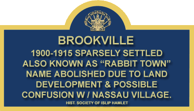
Clearly, during the late 1880's through 1915 the northern portion of Islip hamlet was designated as the separate and distinct hamlet of Brookville. Interestingly, were it not for an errant delivery of a postal letter or package, this area may still be known as, "Brookville". Despite all of the written primary and secondary sources regarding Brookville, the name of the area remains well-known among some older denizens of Islip hamlet humorously as "Rabbit Town" or "Rabbit City".

Footnotes:
[1] Havemeyer, Harry W., "Along the Great South Bay," Amereon House, Mattituck, NY,pp.385.
[2] Ibid., Havemeyer, Harry W. p.
[3] Islip Bulletin, Van Sidden, Edward, Memorabilia of Islip Village, installment 24. 1969.
[4] Letter to Islip Postmaster Heidi Roberts regarding records of a Brookville hamlet serviced by the Islip Post Office dated.
[5] Newsday, Friday, January 10, 2003, Real Estate Section, p. C5.
[6] Baldwin, Richard P., letter dated March 11, 2002 regarding Baldwin family history in Village of Brookville also known as "Baldwinsville".
[7] Islip Town Board minutes, May 1907, p.99.
[8] South Side Signal, March 9, 1907, p.2.
[9] Smith, Dr. Ray T., letter dated August 5, 2003 regarding the Beta Sigma Phi Fraternity at Islip High School sponsored, "Minstrel Show" and 1889 map of land development of Village of Brookville.
From the research paper titled "Brookville" by Robert H. P. Finngan